New street-level wayfinding system to be piloted


New wayfinding signs will be coming to the streets of Yishun and the Central area this month. A total of 35 kiosks, totems, and fingerposts will be installed across the locations to help pedestrians and cyclists better navigate to key amenities. These include MRT stations, bus stops, cycling paths, and other major landmarks.
This pilot initiative is part of efforts to make walking and cycling journeys to key amenities more convenient and accessible.
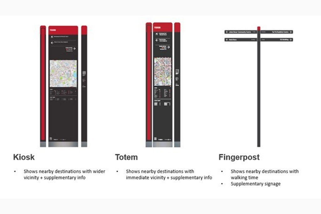
The kiosk will show nearby destinations within the wider circumference, whereas the totem signs tell the location of places within the immediate vicinity. Both will also provide supplementary information on the location of facilities such as building entrances, landmarks, MRT stations, bus stops, taxi stands and cycling paths, said LTA.
The fingerpost sign will serve as a supplementary signage to let users know that they are heading in the direction of their intended destination.
To help users orientate themselves in relation to their surroundings, the signage will also feature familiar wayfinding icons such as the "You are here" indicator, and 3D landmarks.
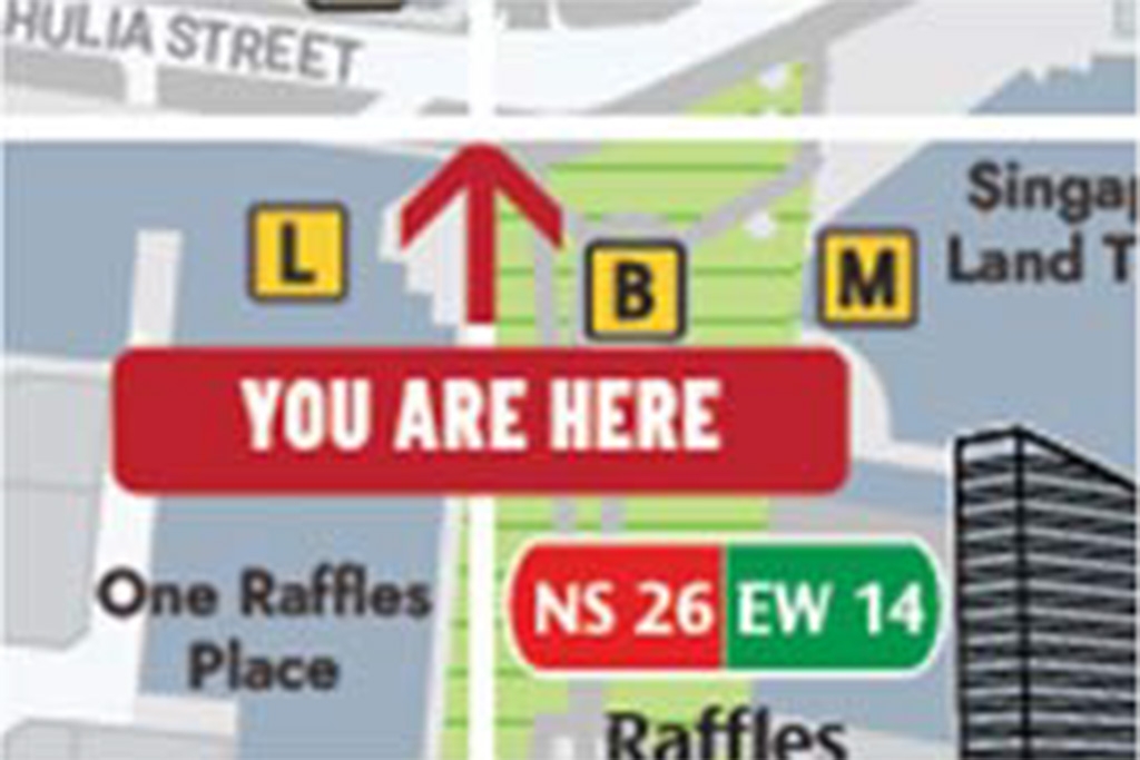
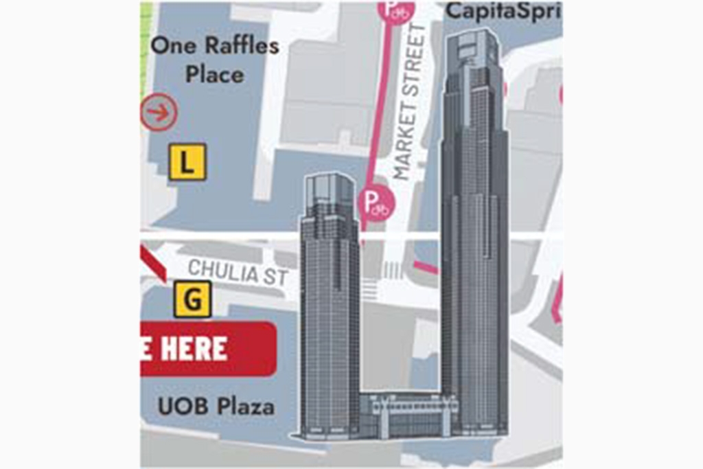
These icons will help pedestrians and cyclists find their way to nearby key destinations, landmarks, public transport nodes as well as active mobility infrastructure, including bicycle parking and cycling paths.
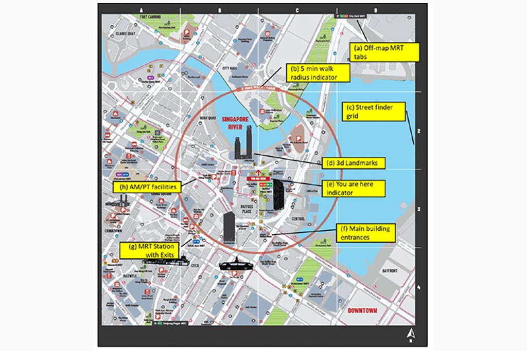
Other features include:
- Off-map MRT tab, which shows the general direction of the next nearest MRT station outside the map extent
- Five-minute walk radius indicator, which indicates the general area within five minutes or 400m from the user's current location
- Street finder grid, that offers easy reference to legend for users to find streets on the map
- Main building entrances featuring an arrow, to allow users to easily identify where to enter the building so
that they can navigate accordingly - MRT stations with exits so users can easily find their way to the entrances/exits within proximity
- Active Mobility/Public Transport facilities and amenities to encourage the use of walking, cycling and taking public transport
LTA said it will conduct surveys and interviews to evaluate how this wayfinding system, featuring physical markers and familiar wayfinding icons, can complement existing tools like navigation mobile applications.
If this pilot proves successful, this system will support the Island-wide Cycling Network and be integrated as a feature of Friendly Streets, added the authority.
Guidelines may be developed, if assessed necessary, to set out standards and best practices for street-level wayfinding signage design and placement.
Since December 2020, LTA has been conducting a series of street surveys, workshops, focus group discussions and roadshows involving residents, visitors and various stakeholders to gather feedback and gain insights into their navigation experiences.
These yielded suggestions on improvements to iconography, map scale and colour scheme, which are now incorporated into the signage design and placement locations for the pilot.
This is the first time Singapore is testing out such an elaborate wayfinding system on our streets. Existing wayfinding systems are typically found in the local malls. Similar systems that are already in place include those used in Sentosa Island and London.
New wayfinding signs will be coming to the streets of Yishun and the Central area this month. A total of 35 kiosks, totems, and fingerposts will be installed across the locations to help pedestrians and cyclists better navigate to key amenities. These include MRT stations, bus stops, cycling paths, and other major landmarks.
This pilot initiative is part of efforts to make walking and cycling journeys to key amenities more convenient and accessible.
The kiosk will show nearby destinations within the wider circumference, whereas the totem signs tell the location of places within the immediate vicinity. Both will also provide supplementary information on the location of facilities such as building entrances, landmarks, MRT stations, bus stops, taxi stands and cycling paths, said LTA.
The fingerpost sign will serve as a supplementary signage to let users know that they are heading in the direction of their intended destination.
To help users orientate themselves in relation to their surroundings, the signage will also feature familiar wayfinding icons such as the "You are here" indicator, and 3D landmarks.
These icons will help pedestrians and cyclists find their way to nearby key destinations, landmarks, public transport nodes as well as active mobility infrastructure, including bicycle parking and cycling paths.
Other features include:
- Off-map MRT tab, which shows the general direction of the next nearest MRT station outside the map extent
- Five-minute walk radius indicator, which indicates the general area within five minutes or 400m from the user's current location
- Street finder grid, that offers easy reference to legend for users to find streets on the map
- Main building entrances featuring an arrow, to allow users to easily identify where to enter the building so
that they can navigate accordingly - MRT stations with exits so users can easily find their way to the entrances/exits within proximity
- Active Mobility/Public Transport facilities and amenities to encourage the use of walking, cycling and taking public transport
LTA said it will conduct surveys and interviews to evaluate how this wayfinding system, featuring physical markers and familiar wayfinding icons, can complement existing tools like navigation mobile applications.
If this pilot proves successful, this system will support the Island-wide Cycling Network and be integrated as a feature of Friendly Streets, added the authority.
Guidelines may be developed, if assessed necessary, to set out standards and best practices for street-level wayfinding signage design and placement.
Since December 2020, LTA has been conducting a series of street surveys, workshops, focus group discussions and roadshows involving residents, visitors and various stakeholders to gather feedback and gain insights into their navigation experiences.
These yielded suggestions on improvements to iconography, map scale and colour scheme, which are now incorporated into the signage design and placement locations for the pilot.
This is the first time Singapore is testing out such an elaborate wayfinding system on our streets. Existing wayfinding systems are typically found in the local malls. Similar systems that are already in place include those used in Sentosa Island and London.

Latest COE Prices


